
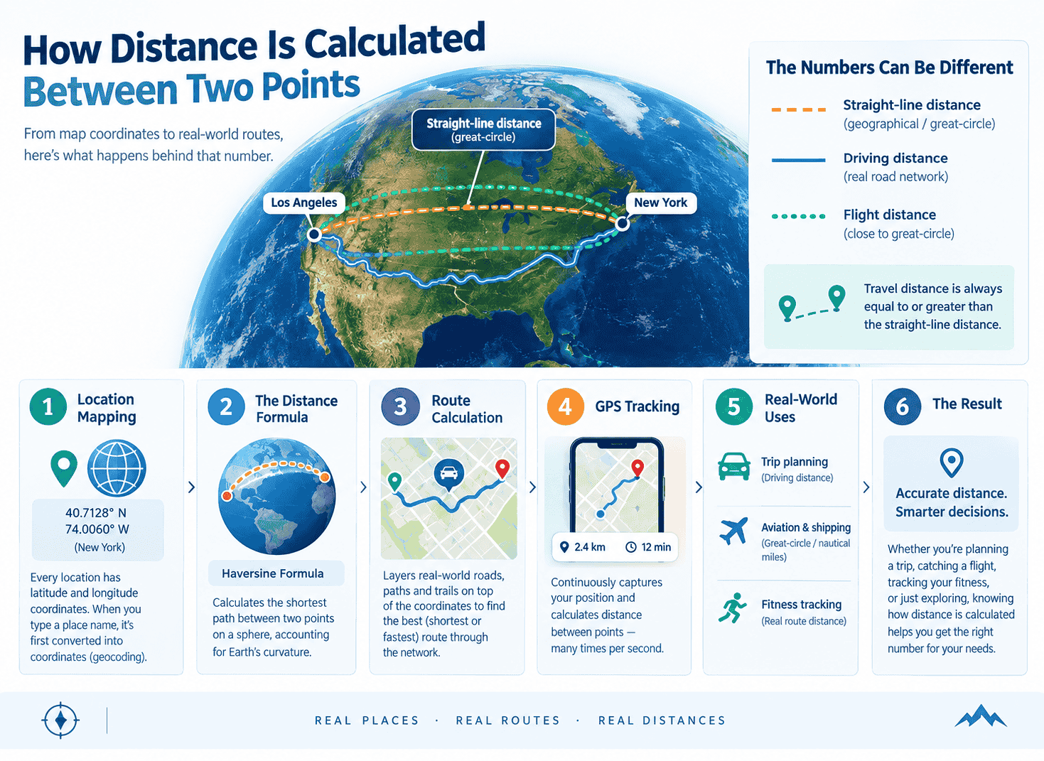
When you type two places into a distance calculator and hit “Calculate,” a lot happens in that split second — coordinates get compared, a formula runs, and a number appears. But what’s actually happening behind that number? Understanding how distance measurement really works makes the result far more useful than just taking it at face value.
Straight-Line Distance vs. Travel Distance
Not all distance is the same distance. Two very different numbers hide behind that one word, and mixing them up is the most common source of confusion.
Geographical distance — often called “as the crow flies” — is the straight-line distance between two points, measured directly through space, ignoring roads, terrain, or obstacles entirely. It’s the shortest mathematically possible line connecting two locations on Earth’s surface.
Travel distance is something else entirely: the actual distance you’d cover moving along a real route — a road for driving, a trail for walking, a path for cycling. Travel distance is always equal to or greater than the straight-line distance, because real routes bend around rivers, buildings, mountains, and one-way streets. This is exactly why a tool like ours shows different results for Driving, Walking, and Cycling — each pace runs its own real-world route calculation, not just a scaled-down version of the same straight line.
How Map Coordinates Define Any Location
Every calculation starts in the same place: location mapping. Every point on Earth’s surface has two numbers attached to it — latitude (how far north or south of the equator) and longitude (how far east or west of the Prime Meridian). Together, these map coordinates pin down a location precisely enough to distinguish one specific street corner from another, anywhere on the planet.
When you type “New York” into a distance calculator, the tool doesn’t actually understand the word “New York” — it converts that text into a coordinate pair (a process called geocoding) before any math happens at all. Everything that follows depends on getting that first coordinate lookup right.
The Distance Formula: How Point-to-Point Distance Gets Calculated
Once both locations exist as coordinates, the distance formula takes over. Here’s the part that surprises a lot of people: you can’t just reach for ordinary geometry, because Earth isn’t flat.
On a flat map, you’d calculate distance between two points with simple Pythagorean geometry. But since the Earth is a sphere (technically, a very slightly flattened one), a straight line between two coordinates has to curve to follow the planet’s actual surface. This is where the Haversine formula comes in — an equation built specifically for this problem. It accounts for Earth’s curvature and calculates the shortest path between two points along the surface of a sphere, known as the great-circle distance.
This is also why the fastest flight path between two far-apart cities often looks curved when you see it on a flat map, even though it’s genuinely the shortest possible route — the curve is a side effect of squashing a sphere onto a flat image, not an actual detour.
From Formula to Route Calculation
Great-circle distance answers “how far apart are these two points” — but it doesn’t answer “how do I actually get there.” That’s a different, more complex problem called route calculation, and it’s what powers turn-by-turn navigation.
Route calculation starts from the same coordinates, then layers real-world road, path, and trail networks on top, and calculates the shortest (or fastest) path through that network instead of through open space. This takes meaningfully more computing than straight-line distance, which is part of why a road closure can reshape an entire route in an instant.
How GPS Uses These Same Principles
Every time your phone or car shows you moving along a route in real time, it’s applying this same foundation continuously. GPS distance tracking works by repeatedly capturing your current map coordinates through satellite signals, then calculating the distance between your last known position and your new one — many times per second. String enough of those tiny point-to-point distance calculations together, and you get a smooth, constantly updating read on both your current travel distance and how far you have left to go.
Why This Actually Matters
This isn’t just trivia — knowing the difference between geographical distance and travel distance changes how you should read the results from any mileage calculator:
- Trip planning. Driving distance tells you what to expect on the road. Straight-line distance tells you almost nothing useful for a road trip.
- Aviation and shipping. Flights and ships travel close to the great-circle distance, since open air and open water don’t have roads to follow — which is exactly why these industries lean on nautical miles and straight-line calculations rather than driving distance.
- Fitness tracking. A cycling or walking app measuring your travel distance needs real route calculation, not a straight line, since real paths curve around real terrain.
Try It Yourself
The easiest way to see all of this in action is to run the numbers yourself. Our free distance calculator shows you straight-line distance in kilometers, miles, and nautical miles, plus real travel distance and time for Driving, Walking, or Cycling — calculated live from map coordinates for any two locations you enter.
Want to see the gap between straight-line and travel distance play out on a real route? Check out our breakdown of the distance from Los Angeles to New York, where the two numbers tell noticeably different stories.